

Availability: All plans
A closed traverse walks the boundary and comes back to where it started. Closure is the measure of how close it gets. This is standard traverse computation, unchanged since long before the software, and Trace shows every step of it.
Latitudes and departures
Break each course into two components. Its latitude is how far north or south it runs, its departure is how far east or west. For a course of length L at bearing angle A measured from north:
- Latitude = L multiplied by the cosine of A, positive north and negative south.
- Departure = L multiplied by the sine of A, positive east and negative west.
Walk a boundary that truly closes and the latitudes cancel to 0 and the departures cancel to 0, because you finished where you began. Real descriptions rarely do. What is left over is the misclosure in latitude and the misclosure in departure, which is exactly what the closure report labels Latitude misclosure and Departure misclosure.
Linear misclosure
Those two leftovers are the legs of a right triangle. The linear misclosure is its hypotenuse, so it is the square root of the departure misclosure squared plus the latitude misclosure squared. That single distance is the gap between where the traverse ended and where it began, and the closure report prints the square root as it computes it.
The direction of that gap is the closure bearing. It points from the terminus back to the point of beginning, which is why the manual plotting tract card offers the same figure as a remainder badge: it is the course you would have to add to close the traverse.
Precision ratio
A gap of 0.02 feet means one thing on a 200 foot lot and another on a 20,000 foot boundary, so the misclosure is expressed against the distance travelled. Divide the linear misclosure by the perimeter and state the result as 1 in n. That is relative precision, and the report shows the division that produced it.
A worked example
A five call tract, four lines and a curve to the right along a road margin, closing on 2.4341 acres.
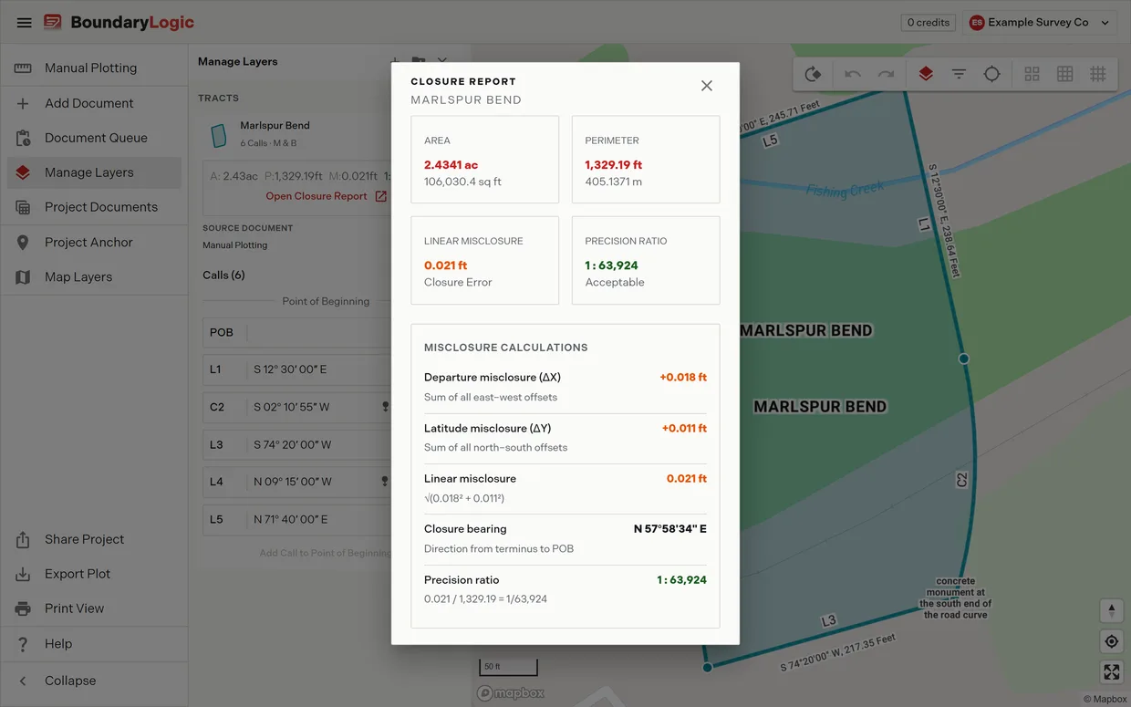
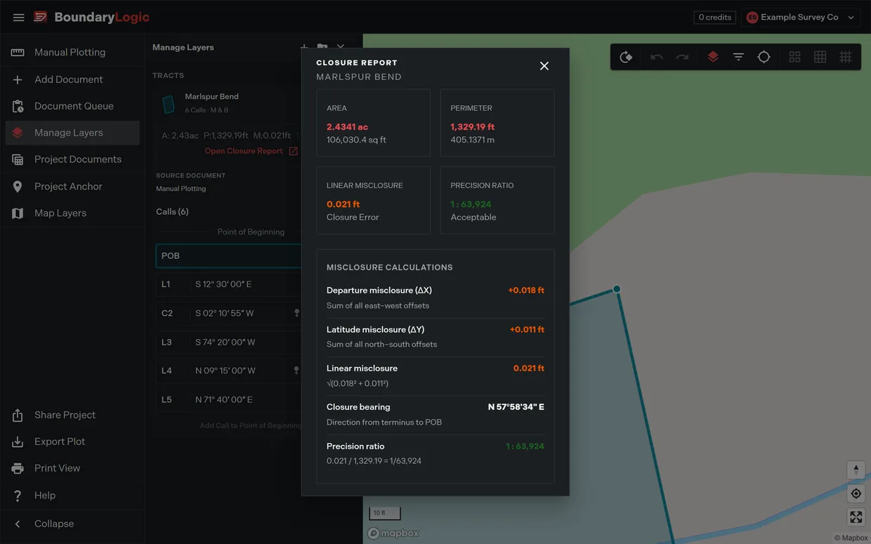
- The departures leave 0.018 ft on the table and the latitudes leave 0.011 ft.
- The square root of 0.018 squared plus 0.011 squared is 0.021 ft. That is the linear misclosure.
- The closure bearing is N 57 58 34 E, the direction you would walk to get back to the point of beginning.
- 0.021 divided by the 1,329.19 ft perimeter gives 1 : 63,924, which the report rates Acceptable.
0.021 feet is a quarter of an inch on a boundary a quarter of a mile round. That is what rounding in recorded bearings and distances looks like.
Two calculations of the same traverse
Trace works the traverse out twice. The manual plotting tract card gives you a live figure that updates as you type, and the closure report gives you a finished figure when you open it. Both are right, and they disagree in the last digit, so a document that quotes one must not quietly quote the other. For the tract in that report:
| Readout | Tract card | Closure report |
|---|---|---|
| Area in square feet | 106,030.49 sq ft | 106,030.4 sq ft |
| Closure error | 0.02 ft | 0.021 ft |
| Precision | 1:63,945 | 1 : 63,924 |
| Direction back to the point of beginning | N 59 46 10 E | N 57 58 34 E |
The precision ratios differ because each divides by a misclosure carried to a different number of places. Quote the one you are actually reading, and say which it was.
What moves the number
- Rounding in the record. Bearings recorded to the nearest second and distances to the nearest hundredth cannot close perfectly. This is the normal case and it lands in the tens of thousands.
- A transcribed call. Two swapped digits in a bearing, a quadrant letter reversed, a distance short by a foot. These move the ratio hard, into the hundreds or worse, and are what Diagnose closure looks for.
- A missing or duplicated call. The remainder is then roughly the length of the call itself, which is the signature to look for.
- Units. A distance in chains, poles or rods entered as feet throws one course badly out of scale.
- Curves. A curve solved from radius and arc closes differently than one solved from a chord, and an ambiguous curve direction reverses a whole bulge.
Closure does not check that every call was read
Everything on this page measures the calls Trace could read. A call Trace cannot read is marked with an error beside its line in the manual plotting editor and then left out of the traverse, and the area, perimeter and closure are reported as though that call had never been written. The arithmetic is right for the calls that remain. It says nothing about the one that is gone.
Whether the loss shows depends on where it falls. Drop one side of a four sided tract and the misclosure is roughly the length of the missing line, which tells you at once. But where the dropped call sits between two courses that double back on each other, the traverse still returns to where it started, and Trace reports Closed in green with no closure error against it. A description missing an entire boundary line can read as closed.
So the closure figures answer “do the calls I read come back to where they started”. They never answer “did I read all the calls”. Nothing in Trace compares the calls it plotted against the description in your hand, so that count is yours to make. When a call will not plot covers finding a dropped call, and Read your description before you upload it is the check to run first.
What closure is not
Closure measures the internal consistency of the description as written. It says nothing about whether the description matches the ground, whether the calls were read from the right instrument, or whether the tract is the one intended. A deed plot is the record boundary, and while Trace shows the checks, the reviewing professional does the verifying.
Closure is also not the same measure as relative positional precision. ALTA/NSPS sets relative positional precision for a land title survey at 0.07 feet plus 50 parts per million, and that is a standard for field measurement between monuments, not a closure standard for a recorded description. Do not read one as the other.
Sources
- Ghilani and Wolf, Elementary Surveying: An Introduction to Geomatics, for latitudes and departures, linear misclosure and relative precision.
- ALTA/NSPS, Minimum Standard Detail Requirements for ALTA/NSPS Land Title Surveys, for relative positional precision.
Related
- The closure report, for opening the report these figures come from
- Reading the precision ratio, for the thresholds to act on
- Verifications, for the same checks on the tract card
- The corridor report, for why a centerline easement has no closure at all