
Put the plot on the map where the description says it is.
A plotted boundary starts with no position on the earth. Move it onto the basemap by street address, by latitude and longitude, or by the township, range, and section the description already carries.
- Address, coordinates, or PLSS reference
- Township, range, section, then the quarter
- PLSS placement on Professional and above

Draft the traverse from the document.
Upload a deed or easement and Trace reads the legal description and drafts the calls for you. The draft arrives with its checks computed, so review starts at the math, not at the keyboard.
- Reads PDFs, scans, and text
- Bearings, distances, and curves
- Checks shown for review
Plot by hand, free forever.
Enter calls with the quadrant shorthand you already know and watch the plot draw as they land. Manual plotting, PDF export, and DXF export cost nothing, with no license and nothing to install.
- Quadrant shorthand entry
- Curves and PLSS calls
- PDF and DXF export included
Export to your client, CAD, and GIS.
Send a finished plot out as a PDF for the file, DXF for CAD, or Shapefile, KML, and GeoJSON for GIS. Custom title blocks and logos are available on Expert, and exports never cost a credit.
- PDF, DXF, SHP, KML, GeoJSON
- Custom title blocks on Expert
- Exports never cost a credit
See the math on every tract.
Area, perimeter, closure error, and remainder to the point of beginning are computed live as you plot. Every tract shows its precision ratio, so a professional can verify before it goes out.
- Area and perimeter
- Closure error and precision
- Remainder to the POB
See every tract in the project on one drawing.
A fullscreen drawing canvas that renders every active document in the project, and their child tracts, together on a grid. Toggle labels and layers, then export a DXF that matches the sheet.
- Every active document at once
- Label and layer toggles
- Included on the free plan
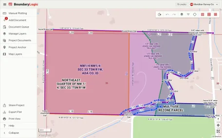
See the plot in real-world context, with every layer under your control.
Anchor the project, pick a map mode, and use manage layers to decide what is visible, what is locked, and what draws on top. Hiding a layer comments it out of the drawing and never deletes it.
- Sheet, streets, satellite, and 3D modes
- Visibility, order, lock, and tract names
- Sheet and streets are free; the rest are on paid plans
Locate against section, township, and range.
Tie a plot to the Public Land Survey System and place it by aliquot part. Section, township, and range references are read from the description and drawn in place.
- Section, township, and range
- Aliquot part placement
- Read from the description
Every project, its status, and who is on it, on one screen.
The projects view lists the work with its status, and search, sort, and filter narrow it down. Personal labels come with Professional, shared categories with Expert, and archiving keeps a finished job without losing it.
- Statuses, labels, and categories
- Search, sort, and filter
- Archive rather than delete
Drop the plat under the plot.
Bring a plat, aerial, or survey scan onto the canvas as its own layer, then place, scale, rotate, and fade it until it lines up with the traverse. It sits alongside tract layers in manage layers.
- Place, scale, rotate, and set opacity
- Rename, lock, and reorder as a layer
- Professional and above
Run the team, control the spend, and deliver under your name.
Expert adds the team-wide projects view, shared categories, roles and per-member permissions, client-ready shared project links with your title block and logo, reports, and admin billing against one pooled balance.
- Team-wide view and shared categories
- Owner, admin, member, and guest roles
- Shared links, reports, and admin billing