

Availability: All plans. Role: edit access on the project.
You have a metes and bounds description and nothing to upload: it is on paper, or it is a scan no one can pull text out of. This guide types one into BoundaryLogic Trace call by call and ends with a PDF plot sheet for the file. Nothing is uploaded and nothing is read by AI. You type it.
Manual plotting is free forever on every plan and consumes no credits, so this whole guide runs on a Free account.
What you will need
- A project in Trace, and edit access on it. Without edit access the workspace sends you back to the project map.
- The description in front of you.
The description we are plotting
Five calls: four lines and a curve to the right along a road margin, closing on 2.4341 acres.
BEGINNING at a capped iron rod set at the west margin of Kiln Ridge Road, at the southeast corner of the Ridout tract;
thence with the west margin of Kiln Ridge Road, S 12 30 00 E, 238.64 feet;
thence continuing with the west margin of Kiln Ridge Road on a curve to the right having a radius of 400.00 feet and an arc length of 205.00 feet, to a concrete monument found at the south end of the road curve;
thence leaving the road and with the north line of the Nyland tract, S 74 20 00 W, 217.35 feet;
thence with the east line of the Halloway tract, N 09 15 00 W, 422.49 feet, to a stone found at the northwest corner;
thence with the south line of the Ridout tract, N 71 40 00 E, 245.71 feet, to the place of BEGINNING;
containing 2.4341 acres, more or less.
1. Open the manual plotting workspace
In the project menu, click Manual Plotting. A picker opens under the heading Select a document, listing each document with its tract count and last update date. Choose one, or start a blank one and name it. An empty project skips the picker and opens a new document on the single line &( Tract A.
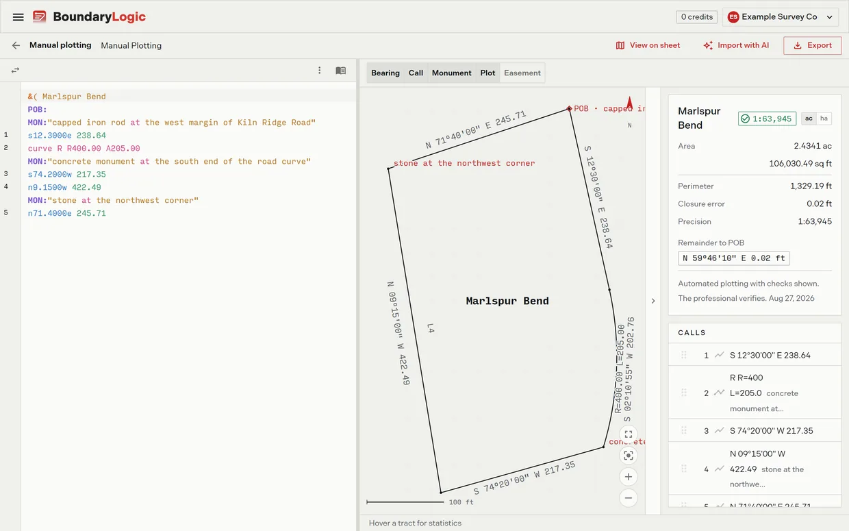
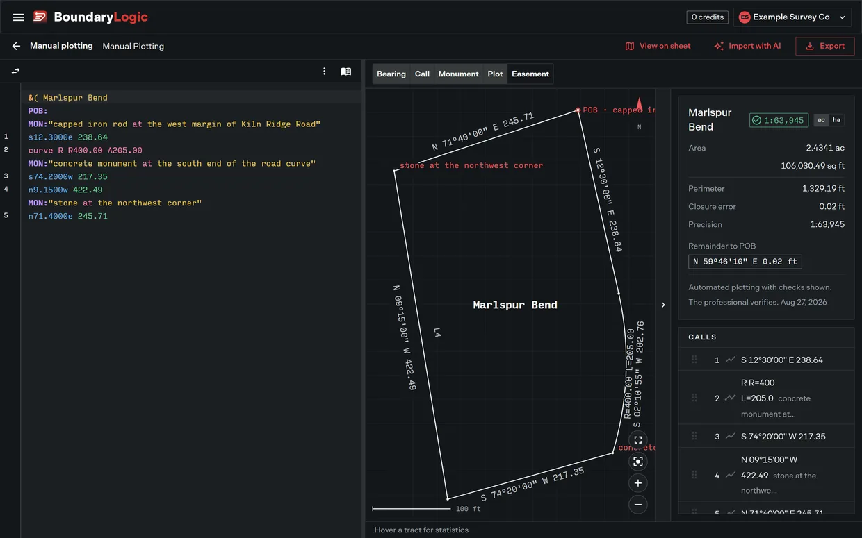
Three panels: the editor you type into, the plot sheet the traverse draws on, and the results panel. Trace redraws all three as you type. There is no save button. The document saves itself about eight tenths of a second after you stop typing, and the badge in the toolbar reports where that got to.
2. Name the tract and set the point of beginning
A tract starts with a header. Type over Tract A, or start a new block:
&( Marlspur Bend
POB:
MON:"capped iron rod at the west margin of Kiln Ridge Road"
A line starting &( begins and names a tract, and everything under it belongs to that tract until the next header. Rename the header later and the legal description is renamed across the project.
A bare POB: marks the point of beginning without placing it in plot coordinates, which is what you want when the record names a monument rather than a position. POB: e1000 n1000 puts it at known local plot feet instead. Where the record commences at a section corner and walks in, use POC: and prefix the tie calls with a slash.
The MON: line attaches to whatever sits closest above it, so this one names the point of beginning itself. Type inside the quotes and Trace offers the standard keywords: iro gives iron pin, iron pipe and iron rod. Tab or Enter accepts one, Escape keeps your own wording.
3. Walk the calls
Write a bearing as the quadrant letter, the degrees, a decimal point, then two digits of minutes and two of seconds. So s12.3000e is S 12 30 00 E. The distance follows in feet unless you add a unit letter. The first call:
s12.3000e 238.64The plot draws it at once and the line is numbered 1 down the left side. Boundary calls number upward from 1, ties number C1 upward, and headers, declarations and comments get no number, which makes those numbers the fastest way to check that Trace read the calls you think you typed.
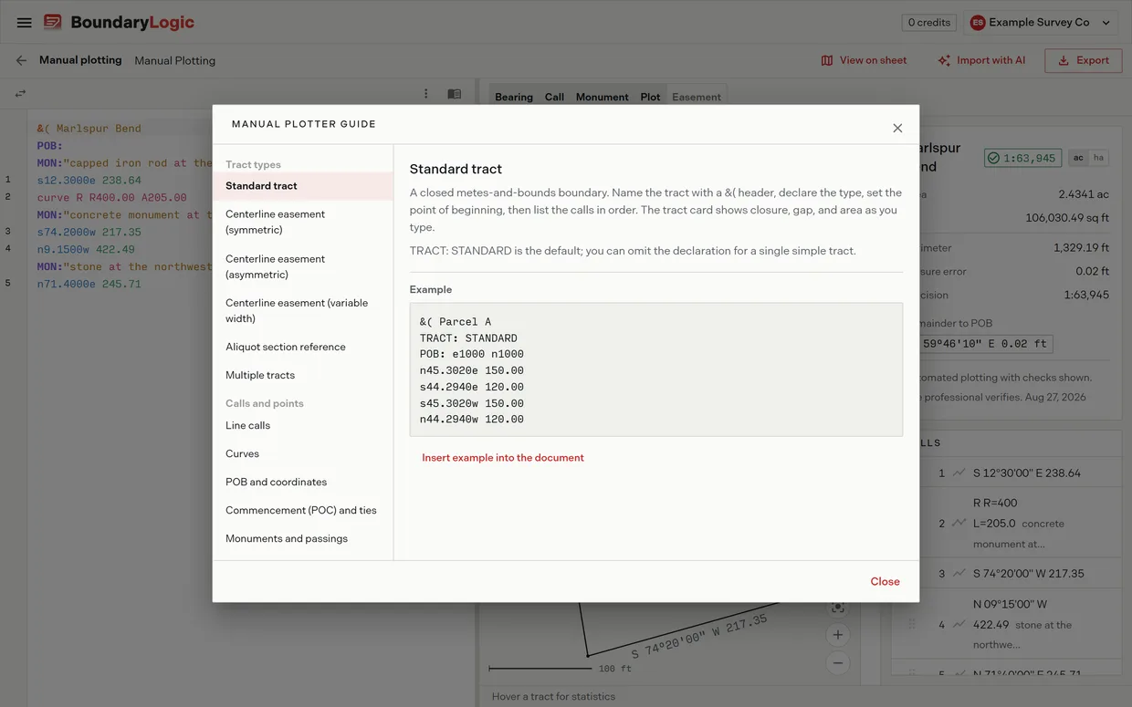
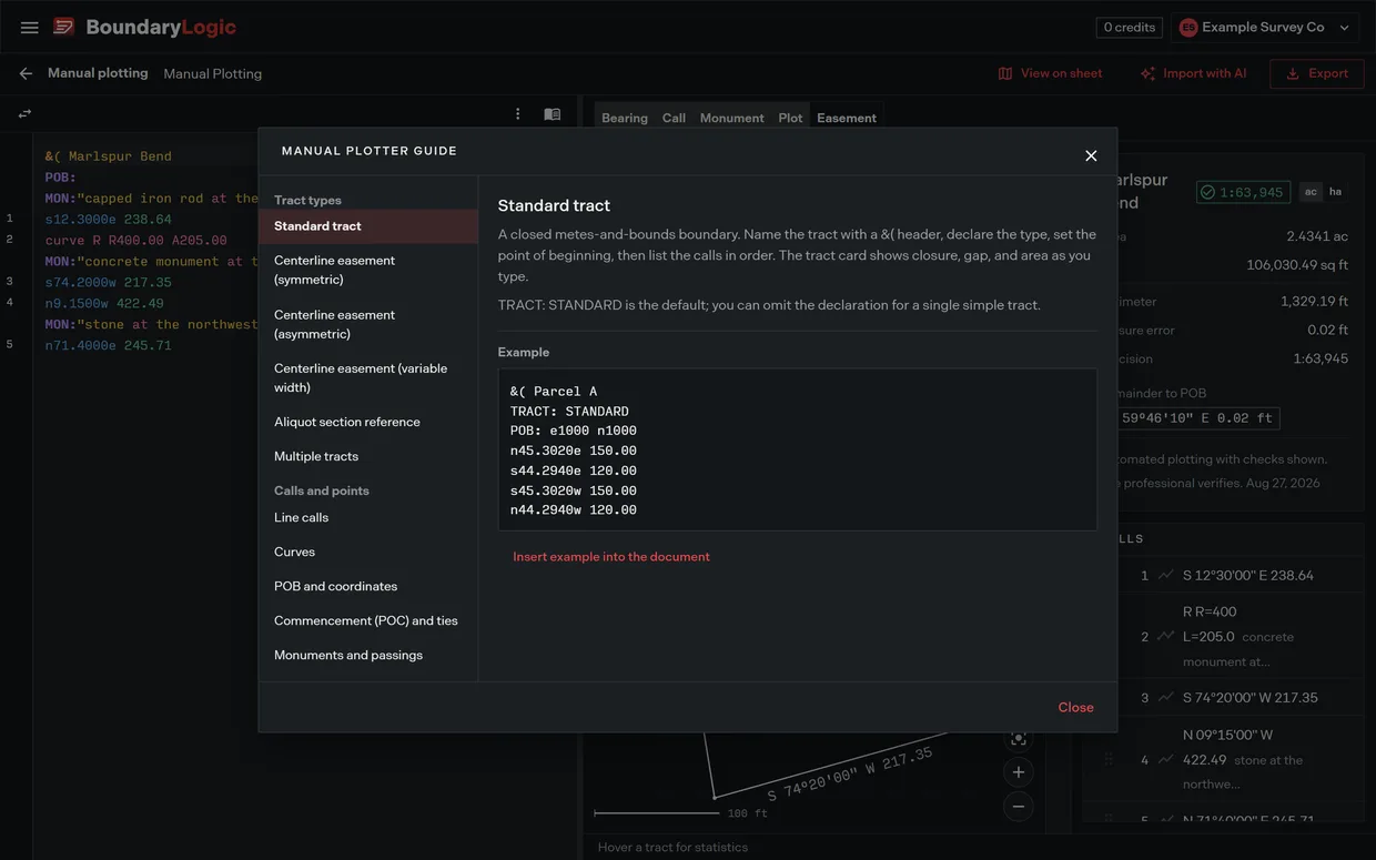
The quadrant form is one of several. Bare azimuths, deflection and interior angles and cardinal shorthand all work, as do distances in meters, chains, rods, poles, links and varas. Click the guide icon on the editor toolbar for the syntax topic by topic, each beside a working example you can insert into your own document and read against a live plot.
Get a call wrong and the line is underlined, an icon marks it, and the message appears on hover or in the status bar for the line the cursor sits on: Line 4: Bearing must be 0-90 degrees. Fix it and the marker clears as you type. A tract Trace cannot read is never saved over geometry you already had.
4. Add the curve
The second call bends with the road. A curve call takes the curve keyword, the hand it turns, then enough parameters to fix the arc:
curve R R400.00 A205.00A curve to the right, radius 400.00 feet, arc length 205.00 feet. Radius with arc is one workable pair; radius with central angle (D29.2151), radius with chord (C202.76) and degree of curve are others. Give Trace a pair that cannot describe one curve and it says so rather than guessing.
This curve is tangent, so it takes its bearing from the call above it. That also means a tangent curve cannot open a tract, because there is nothing there to be tangent to; a curve in that position needs a chord bearing, a tangent or a radial direction.
To fill in fields instead of typing parameters, click New curve and choose the curve type. The preview restates the arc as you work, and it is what confirms this one: arc 205.00, chord 202.76, R 400.00, central angle 29 21 51. Double-click a curve line later to reopen the form prefilled from it.
5. Finish the walk
Three straight calls close the boundary, with monuments named where the record found them:
MON:"concrete monument at the south end of the road curve"
s74.2000w 217.35
n9.1500w 422.49
MON:"stone at the northwest corner"
n71.4000e 245.71
Monuments never move the geometry. They label the plot sheet, ride along in exports, and change no computed value, so record everything the deed says was found. To hang one on a call already typed, write MON@3: "found iron pipe".
The whole tract, ten lines:
&( Marlspur Bend
POB:
MON:"capped iron rod at the west margin of Kiln Ridge Road"
s12.3000e 238.64
curve R R400.00 A205.00
MON:"concrete monument at the south end of the road curve"
s74.2000w 217.35
n9.1500w 422.49
MON:"stone at the northwest corner"
n71.4000e 245.71
6. Read the tract card
The results panel filled in as you typed:
| Readout | Value |
|---|---|
| Area | 2.4341 ac over 106,030.49 sq ft |
| Perimeter | 1,329.19 ft |
| Closure error | 0.02 ft |
| Precision | 1:63,945 |
| Remainder to POB | N 59 46 10 E 0.02 ft |
Check the area first: 2.4341 acres is what the deed recites. The ac and ha buttons restate area, perimeter and closure error in metric.
Then read the badge at the top of the card. It says Closed when the error is under 0.005 feet, and otherwise gives the precision ratio in colour: green at 1:5,000 or better, amber between 1:1,000 and 1:5,000, red under that. This tract reads green at 1:63,945.
The remainder badge gives the bearing and distance that would close the traverse, here N 59 46 10 E for 0.02 feet. On a 1,329 foot perimeter that is a rounding in the record. A remainder in the hundreds of feet means a whole call is wrong, and under 1:1,000 the card offers Diagnose closure, which hunts the single call edit that would most improve the figure and shows each candidate against the line as written. Those are candidates, not corrections. Check them against the source description before applying one.
Closing and being right are not the same thing, and the card says as much: it ends on the line Automated plotting with checks shown. The professional verifies. above today’s date. What you have is the record boundary as the calls describe it, not where anything sits on the ground.
7. Export the plot sheet
In the workspace header, open Export and choose PDF plot sheet. Pending edits flush first, so the sheet comes from what is on screen. Print View opens with a live preview on the left and settings on the right: title, date, who prepared it, notes, which label layers to draw, and whether the disclaimer prints. Click EXPORT AS PDF and the file downloads on its own.
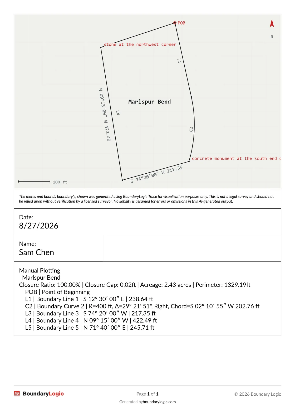
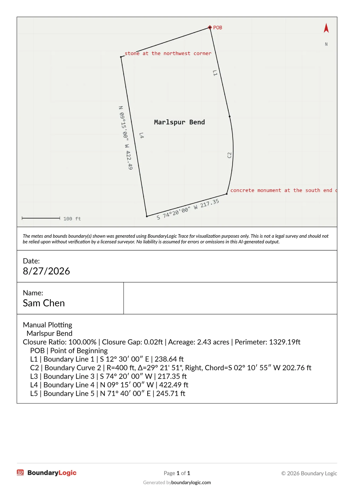
The sheet carries the drawing, the disclaimer, the title block, and a call table for each visible legal description, grouped under its document. This tract prints the point of beginning, then L1, C2, L3, L4 and L5, with the curve broken out into radius, central angle, hand and chord. Its summary line reads Closure Ratio: 100.00% | Closure Gap: 0.02 ft | Acreage: 2.43 acres | Perimeter: 1329.19 ft.
One thing to know before you rely on it: the tables are built from every description currently visible, not from the tract you selected, so hiding the others in Manage Layers is the only way to scope an export. PDF export is open on every plan alongside DXF. Shapefile, KML, KMZ, GeoJSON and PNG need Professional or above.
Where to go next
- The manual plotting workspace, for the panels, the plot sheet controls and the calls list
- Deed syntax reference, for every bearing, distance, monument and declaration form
- Tracts and points of beginning, for declaring a tract and anchoring its start
- Lines curves and calls, for the line and curve forms field by field
- How closure works and Reading the precision ratio, for what the numbers mean
- Export a PDF plat and Export formats, for the sheet settings and the other formats
- Easements and centerlines and PLSS calls in the editor, when the description is a corridor or an aliquot part rather than a closed metes and bounds run