

Availability: All plans. Role: edit access on the project.
Summary
The BoundaryLogic Trace manual plotting editor reads a compact call syntax: one call per line, written close to the way the record reads it. This page lists every form the editor accepts, with the message it returns when a line cannot be read. The same material is in the app under the manual plotter guide, topic by topic beside a working example.
How angles are written. Degrees, then a decimal point, then two digits of minutes and two of seconds. 45.3020 is 45 degrees 30 minutes 20 seconds. Write n45.3020e, not N 45 30 20 E.
Usage notes
Directions
| Form | Write | Reads as |
|---|---|---|
| Quadrant bearing | n45.3020e 150.00 |
N 45 30 20 E, 150.00 feet |
| Degrees only | n45e |
A full 45 degrees |
| Minutes only | n45.30e |
45 degrees 30 minutes, seconds padded |
| Cardinal shorthand | n, e, s, w |
Due north, east, south and west |
| Azimuth | 135.3020 100 |
Clockwise from north |
| Deflection angle | +30 100, -45.30 100 |
Right or left off the previous course |
| Interior angle | +90i 100 |
Off the back bearing of the previous course |
Either quadrant letter takes either case. A bearing over 90 degrees returns Bearing must be 0-90 degrees, and a bad angle returns Minutes must be 0-59 (got 60) or Seconds must be 0-59 (got 60). An azimuth over 360 returns Azimuth must be 0-360 degrees; 360 itself is accepted and normalises to north. A deflection or interior angle on the first call of a traverse has nothing to turn off, so it returns Deflection requires a previous course or Interior angle requires a previous course. Anything unreadable returns Unrecognized direction "zz45q".
Distances and units
A bare number is feet. Every other unit takes a letter, in either case.
| Unit | Letter | Example | In feet |
|---|---|---|---|
| Feet | f or none |
150.00 |
150.00 |
| Meters | m |
100m |
3.280839895 feet per meter |
| Chains | c |
10c |
66 feet each |
| Rods | r |
4r |
16.5 feet each |
| Poles or perches | p |
4p |
16.5 feet each, matching the rod |
| Links | l |
100l |
0.66 feet each |
| Texas varas | v |
36v |
2.777778 feet each |
Compound distances work both spaced and run together: 10c 25l is ten chains plus twenty five links, 676.50 feet, and 3c4p5l is 267.30 feet. A course with passing calls records the points passed and plots the total: e at 100 at 250 in all 500. Passings with no total return Missing distance, as does a call with no distance at all. A field holding anything but digits, unit letters and spaces returns Invalid distance "...", and an unknown letter returns Unknown distance unit "z".
Monuments
A monument labels a point. Monuments never move the geometry: they label the plot sheet and travel with exports without changing a single computed value.
| Form | Write |
|---|---|
| At the call’s end point | n71.4000e 245.71 MON:"iron pipe" |
| At both ends of a call | n0e 500 from MON:"oak tree" to MON:"stone marker" |
| As trailing text on a line call | n 100 found iron pipe |
| On its own line | MON:"iron pin", attaching to whatever sits closest above it |
| Added to an earlier call | MON@3: "found iron pipe" |
| Added to a commencement call | MON@C1: "section corner" |
Repeated MON: lines on one point read as a list joined with a semicolon. A number that does not exist returns No call 9 to attach the monument to, and a missing closing quote returns Unclosed string literal.
A monument description cannot contain a double quote. The syntax has no escape for it, so MON:"5/8" IRF RLS 2263" records only 5/8 and the sheet labels it 5/8. Write inch marks as words, or leave them out.
Curves
A curve call is the word curve, the hand, then enough parameters to fix the arc.
| Parameter | Write | What it sets |
|---|---|---|
| Turn direction | L or R |
The hand, required |
| Radius | R400.00 |
The radius |
| Solve the radius | R? |
From central angle with chord, central angle with arc, or arc with chord |
| Arc length | A205.00 |
The length along the arc |
| Central angle | D90, D112.5307 |
Delta, in degrees or the degrees.minutesseconds form |
| Chord length | C150 |
The chord |
| Degree of curve | DC1.0000 |
Sets the radius from the arc definition, outranking any radius on the line |
| Chord bearing | CBn45e |
Fixes a non tangent curve’s orientation |
| Entry tangent | TANn0e |
Stands in for the previous course’s bearing |
| Radial direction | RADn90e |
Points from the start toward the centre |
| Ahead tangent | AHDn45e |
The tangent leaving the curve |
With no chord bearing, tangent or radial, the curve continues from the course above it. That is why a tangent curve cannot be the first call of a tract or of a commencement traverse: it returns curve data insufficient, which is also what too few parameters returns. A curve with no hand returns Curve requires direction (L or R). Give a curve a chord bearing and it can open a tract on its own.
A central angle over 180 degrees draws as the major arc it describes. A chord equal to the diameter is a legal half circle, but a longer one returns Chord 500 ft is longer than the diameter of 200 ft, and a chord longer than its arc returns Chord 500 ft is longer than the arc of 100 ft. An unknown parameter returns Unrecognized curve parameter "ZZ5".
Monuments go after the parameters, in the same forms as a line call. Free text on a curve line is read as a mistyped parameter and reported, and a MON: placed among the parameters returns Unclosed string literal.
Call prefixes
| Prefix | Effect |
|---|---|
# |
Keeps the call in the document and out of the traverse, the closure, the area and the saved calls. The row stays listed, struck through and dimmed. |
/ |
Marks a tie from the point of commencement to the point of beginning. Draws dashed, numbers C1 upward, never counts toward closure or area. |
from |
A reference call: drawn for reference only, excluded from the boundary, the closure and the area, and never saved. |
? |
A missing call, solved into the closing call the tract needs. |
?L120 |
A missing curve, solved as a curve of that hand and radius. |
Only one missing call is allowed per tract; a second returns Only one missing call allowed per tract. A solved call is marked solved in the calls list, and the tract card says Contains a solved call. The solution is only as good as the other calls.
Tract and point declarations
A line starting &( begins and names a tract, and everything below it belongs to that tract until the next header. Calls written with no header at all plot as one tract named Tract A, and an unnamed header falls back to Tract A, Tract B and so on. A header with no calls under it returns No calls yet. Type bearing and distance calls below this block to draw the tract.
| Declaration | What it declares |
|---|---|
TRACT: STANDARD |
A closed boundary. The default, so it can be omitted. |
TRACT: CENTERLINE 30 |
A symmetric centerline easement, 15 feet each side. |
TRACT: CENTERLINE 20/40 |
Left and right of the direction of travel, so reversing the call order swaps the sides. |
TRACT: CENTERLINE 10/0 |
The whole corridor on one side. |
TRACT: CENTERLINE VARIABLE |
Widths come from the width table. Also accepted as ASYMMETRIC VARIABLE or VARIABLE ASYMMETRIC. |
END: PERPENDICULAR, END: OPEN |
The corridor end treatment, on its own line or inline as TRACT: CENTERLINE 40 END:OPEN. |
An unknown tract type returns Invalid tract type "WOBBLE" and an unknown end treatment returns Invalid end treatment "ROUNDED". A zero or negative width returns Width must be positive number, and zero on both sides returns Width must be positive on at least one side. A variable width run that no row covers returns Width not specified for calls 2 to 3.
Points take three forms each. POB: e1000 n1000 places the point of beginning in local plot feet, accepting an m suffix for meters and negative values. A bare POB: marks where it falls and lets the ties above decide the position. POB: @section 14 T3N R5W ties it to a section and keeps the text as the point’s label. POC: takes the same three forms for the point of commencement, and the older COMMENCE: spelling still works. An unreadable coordinate returns Invalid POB coordinate, and a quoted description in the coordinate slot returns POB: takes a placement like “e100 n200”. Describe the monument on its own MON: line below.
Coordinates
A bare e0 n0 line sets the origin when no declaration places the tract. Later coordinate lines each become a course from the previous point. A boundary that does not return to its start returns Coordinate boundary does not close - last coordinate must return to the POB. To turn typed coordinate lines into bearings and distances, use Coords to calls.
Width tables
A width table row overrides the declared corridor width across an inclusive range of call numbers.
| Row | What it sets |
|---|---|
WIDTH: 1-2: 80 |
A strip width across calls 1 to 2 |
WIDTH: 1-2: 20/40 |
Left and right separately; 10/0 for one side only |
WIDTH: 1-2: 50 to 40 TAPER |
Changes width smoothly instead of jogging at the range ends |
WIDTH: 2-2: 50 to 40/constant |
Carries the previous row’s width on the constant side |
WIDTH: 1-2: L:50 R:BOUNDARY |
Explicit sides, where BOUNDARY rides the centerline |
WIDTH: 1-2: N:45 S:60 |
Cardinal sides, resolved per course |
A trailing STEP or TAPER sets the transition; STEP is the default. Rows grouped between WIDTH_TABLE: and END_WIDTH_TABLE may drop the WIDTH: prefix. Where two rows overlap the later one wins, with the caution Overlapping width specifications at calls 2 to 2. A malformed or reversed range returns Invalid width table entry. A cardinal designation on a course too far off the named direction returns Cardinal width designation is ambiguous for a diagonal centerline, and a corridor that would reach the centre of a centerline curve returns Inside offset exceeds curve radius.
Aliquot sections
ne,14,3n,5w expands to a closed tract on the nominal 5,280 foot standard section. Parts are written section outward from the smallest: quarters ne nw se sw, halves n s e w, dimensioned strips such as n660, and all. Verified areas: 160.0000 ac for a quarter, 40.0000 ac for sw,ne, 320.0000 ac for a half, 80.0000 ac for n660, and 640.0000 ac for all.
An aliquot line synthesizes its own header, such as Section 14 3n 5w, NE, once anything precedes it, so writing a header above it leaves an empty tract behind. PLSS calls in the editor covers the form that writes these lines for you.
Layout
Blank lines and leading or trailing spaces are ignored, so lay the document out for reading. A line starting // is a comment: it is ignored when plotting, so notes and parked calls can live in the document.
What the editor tells you
Declarations, bearings, distances, unit letters, operators, quoted strings, curve keywords, section references and comments are coloured by the same rules Trace reads the line with, so a miscoloured word is usually a mistyped one. The numbers down the left side of the editor are each line’s call number: C1 upward for commencement ties, 1 upward for boundary calls, and nothing beside headers, declarations, comments or reference calls.
A rejected line gets an error icon beside the line and a wavy red underline; a line Trace only cautions about gets a warning icon and an underline in the string colour. Hover either the text or the marker to read the message, or put the cursor on the line and read it in the status bar.
A rejected line is then left out of the traverse, and the tract reports its area, perimeter and closure as though that line had never been written, so read the error markers before you read the figures. When a call will not plot covers finding one.
On a missing call line the cursor shows the solution as a hint, Ctrl+Enter inserts n90w 200.00, or for a missing curve Ctrl+Enter inserts curve L R120 D112.5307 CB270.0000. Ctrl+Enter replaces the marker with the computed call, taking the whole marker including a missing curve’s hand and radius.
Inside an unclosed MON:" string the editor offers the standard monument keywords and their aliases: typing iro gives iron pin, iron pipe and iron rod, and con gives concrete, concrete monument and concrete marker. Tab or Enter inserts the name and closes the quoted string, stepping over a quote already there rather than doubling it. Escape closes the list and keeps whatever you typed.
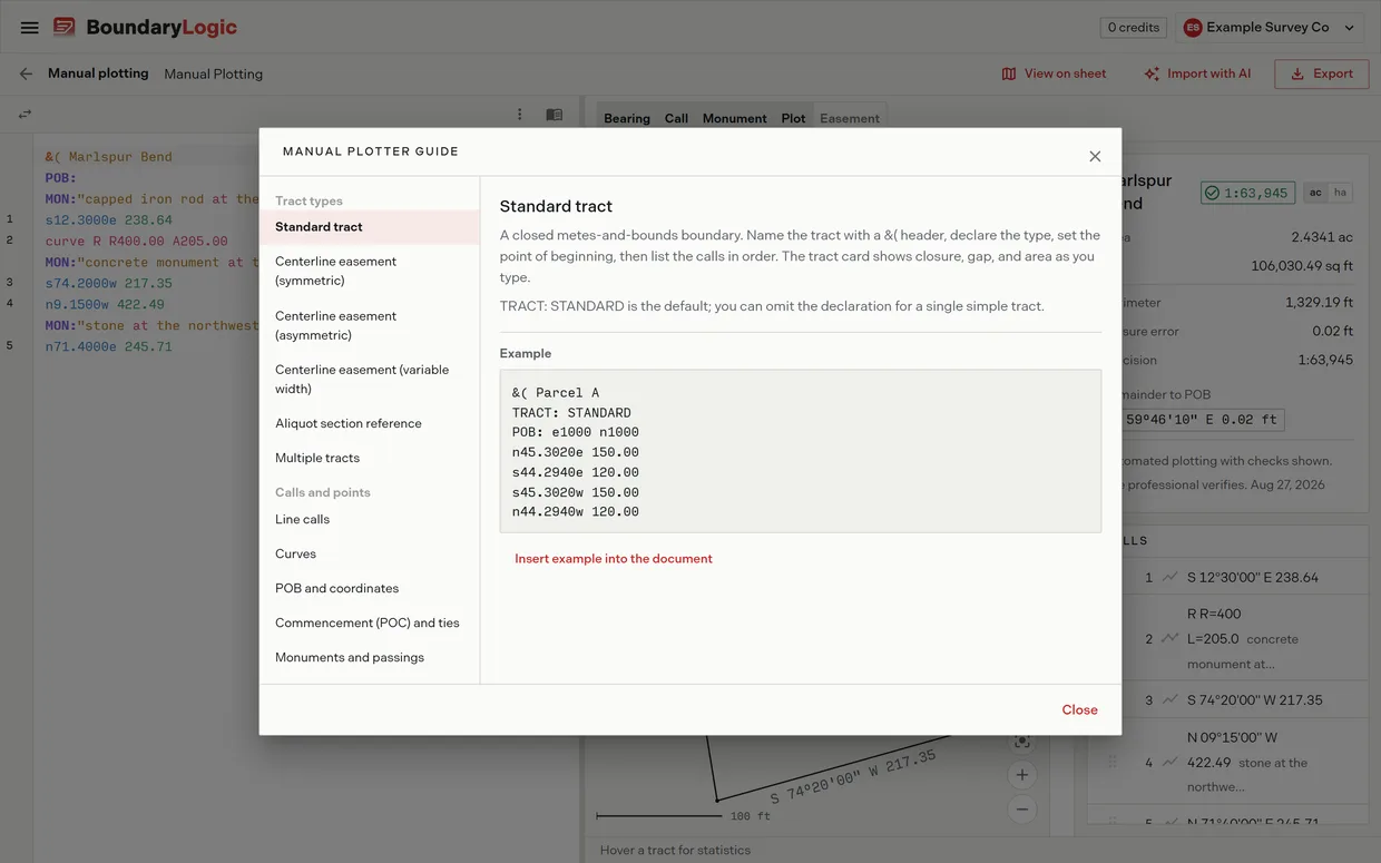
The manual plotter guide
The book icon on the editor toolbar opens the guide: the syntax topic by topic beside a working example of each, in the groups Tract types and Calls and points. Eleven topics: Standard tract, Centerline easement (symmetric), Centerline easement (asymmetric), Centerline easement (variable width), Aliquot section reference, Multiple tracts, Line calls, Curves, POB and coordinates, Commencement (POC) and ties, and Monuments and passings.
Every example works as written. Insert example into the document appends it to the end of the document and closes the guide, so you can read the syntax against a live plot.
A worked example
The BoundaryLogic canonical example tract, Marlspur Bend, is five calls: four lines and a curve to the right along a road margin, with three monuments. This is its editor text exactly as typed.
&( Marlspur Bend
POB:
MON:"capped iron rod at the west margin of Kiln Ridge Road"
s12.3000e 238.64
curve R R400.00 A205.00
MON:"concrete monument at the south end of the road curve"
s74.2000w 217.35
n9.1500w 422.49
MON:"stone at the northwest corner"
n71.4000e 245.71
Three things to read out of it. The bare POB: marks the point of beginning without placing it in plot coordinates. Each MON: line attaches to whatever sits closest above it, so the first attaches to the point of beginning and the second to the curve. The curve is tangent, taking its bearing from the call above, which is why it cannot be moved to the top of the tract.
Related
- The manual plotting workspace, for the panels this text draws into
- Lines curves and calls, for the forms that write these lines for you
- Tracts and points of beginning, for tract headers and start points
- Easements and centerlines, for corridors and width tables
- Editor tips and shortcuts, for the keyboard and selection